CAR GUARD SYSTEMS
CARGUARD IntelliRoute TR8040 Truck navigation system
Item number NAINTR84
Item number NAINTR84
Professional 7" touch Android navigation system for lorries
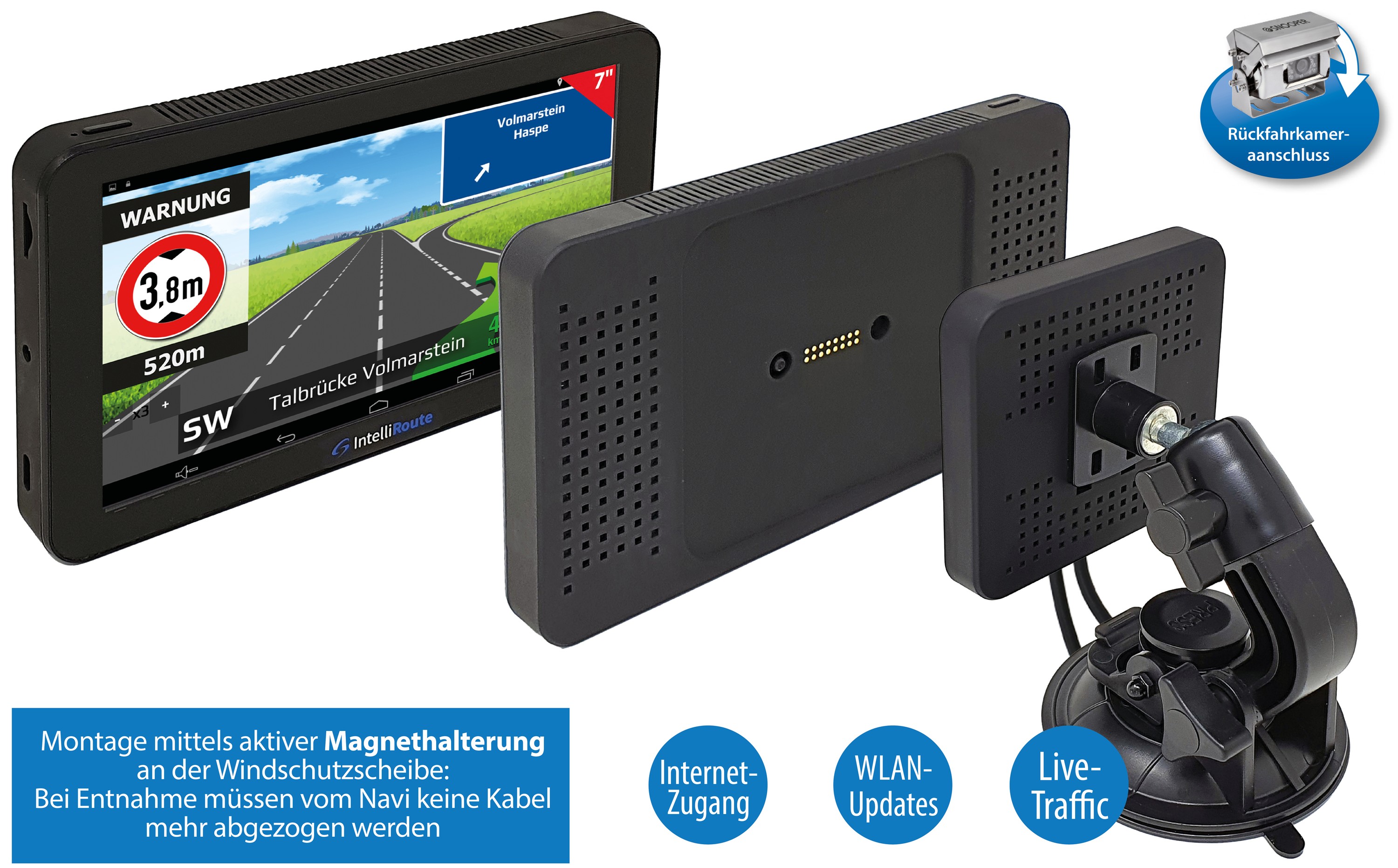
IntelliRoute TR8040 with reversing camera connection, WLAN updates, active magnetic holder and Android app expansion options
Advantages over car sat nav:
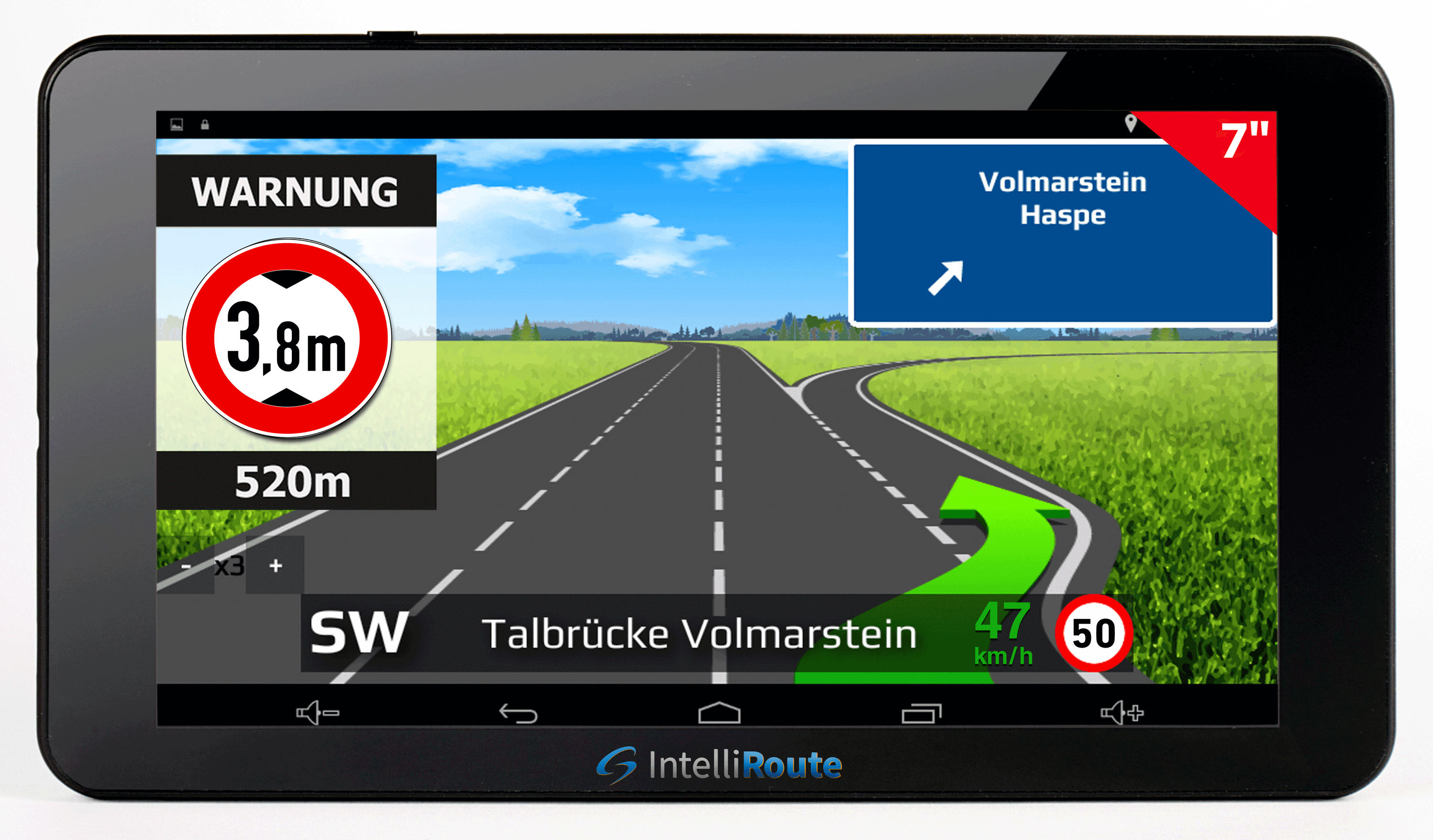
IntelliRoute creates a route based on the characteristics of your vehicle. Simply tell the device the size, weight, load type, emission class and others, and the specialised software will calculate a safe, truck-friendly route. Routes are calculated based on roads of appropriate width and height, avoiding low bridges or weight restrictions and many other hazards.
Google Playstore
In the Google Playstore you can freely download apps via WiFi and enjoy additional functions on your IntelliRoute Android navigation system.
Functional description:
- Mounted on the windscreen using an active magnetic holder: no more cables need to be disconnected from the sat nav when removing it!
- Route guidance taking into account vehicle size (height, width, length), weight, lorry type (with/without/type of trailer), lorry ban, trailer ban, turning ban, turning ban, prohibited load types, hazards (inclines, declines, bends, crosswinds, bumps, schools), tunnel restrictions and environmental zones.
- Free lifetime Here Global map updates for 50 countries (including 36 with lorry-specific navigation)
- Here Global map updates via WiFi (no computer required)
- Search option for lorry parking spaces in Europe
- MP3 player / MP4 player
- Built-in WiFi
- Internet access*
- Google voice search
- Android operating system with Google Play Store
- Any apps from the Play Store can be used
- Speed camera/hazard warning system: optional (free of charge)
- Active lane assistant for near and far (Lane Guidance)
- 3D junction views (Junction View)
- The arrival time forecasts can be set for specific vehicles (+/- 25%)
- Uphill or downhill gradients can be avoided on request (selectable between 9% and 20%)
- Multi-routing 7 tours with up to 16 intermediate destinations each can be saved (manual or automatic sequence)
- Route guidance by entering GPS coordinates (3 different input options can be selected)
- Truck-specific POIs such as truck parking spaces, truck petrol stations, truck workshops, snack bars and toilets (POIs can be imported)
- Over 2 million POIs (with telephone numbers) and search along the route - csv file can also be imported (e.g. from Excel)
- Free online live traffic jam avoidance (mobile internet access/WiFi required, consumes approx. 400MB/month*)
- Truck-specific locations of permanently installed speed cameras
- Map view: 2D view and 3D view
- Option to save your favourites
- Truck and optional car mode
- Tunnel recalculation
- Navigate according to OVI symbols or a motorway exit on the map
- Legal vehicle-specific speed warning system
Device information:
- Mounted on the windscreen using an active magnetic holder: no more cables need to be disconnected from the sat nav when removing it
- Rear view camera connection
- Internet access and installation of additional apps possible
- Online live traffic jam avoidance
- Automatic recognition of video input signals
- 7 touch display
- Screen resolution: 1024 x 600 pixels
- Processor (CPU): Processor: Quad Core ARM Cortex A53 with 1.5 GHz
Lifetime Hero card updates worth 159,- free of charge
Complete scope of delivery mobile IntelliRoute navigation systems:
- Suction cup mount with active magnetic mount for the sat nav
- 12 / 24 V car charger
- data cable
- Operating instructions (installed on the device)
- Rear view camera cable 2.5 mm jack to cinch
- 110 / 230 V power supply unit
- 3M dashboard adhesive plate
Optional accessories:
- Vehicle-specific bracket
- Colour reversing cameras
- 7 Sun visor
- Hard wiring kit
*Smartphone / tablet and / or mobile internet access or WLAN required, Live Traffic Service consumes only 400 MB if used 8 h per day / 20 days per month.
Features common to all IntelliRoute models:
IntelliRoute has the answer
This unique software creates a route based on the characteristics of your vehicle. Simply tell the device the size, weight, load type, emission class and tunnel category (if required) and the specialised software will calculate a safe, truck-friendly route. Routes are calculated based on roads of appropriate width and height, avoiding low bridges or weight restrictions and many other hazards. The route warnings are also issued without entering a destination!
Restrictions that are taken into account during route guidance:
- Height
- Width
- Length
- Weight
- No lorries allowed
- No trailers allowed
- Low emission zone
- No turning possibility for lorries
- No right turn for lorries
- No left turn for lorries
- Lorries with hazardous goods prohibited
- HGVs with water-damaging freight prohibited
Warnings to make you safer:
- Steep incline ahead
- Steep gradient ahead
- Tight bend ahead
- Crosswinds
- Bumps
- Schools
Input of vehicle-specific data from up to 10 different vehicles:
Trailer type:
- Lorry without trailer
- Lorry with 1 trailer
- Lorry with 2 trailers
- Lorry with 3 or more trailers
- Trailer: e.g. avoids roads on which vehicles with trailers are prohibited
- articulated lorry or tractor with one or more trailers
Load type:
- None (Normal)
- Dangerous goods
- Explosive and flammable
- Harmful to water
ADR tunnel code:
- None
- B
- B/D
- C
- C/D
- D
- E
- B1000C
- B/E
- C5000D
- C/E
- D/E
Here Global road maps of 50 countries, 36 of them with special lorry navigation:
36 countries with specific road attributes for lorries and large vehicles:
Albania, Austria, Belgium, Bosnia and Herzegovina, Bulgaria, Croatia, Czech Republic, Denmark, Estonia, Finland, France, Germany, Greece, Hungary, Ireland, Italy, Latvia, Liechtenstein, Lithuania, Luxembourg, Montenegro, Netherlands, North Macedonia, Norway, Poland, Portugal, Romania, Russia, Serbia, Slovakia, Slovenia, Spain, Sweden, Switzerland, Turkey, United Kingdom.
50 countries road coverage in total:
Andorra, Albania, Austria, Azores, Belarus, Belgium, Bosnia and Herzegovina, Bulgaria, Croatia, Cyprus, Czech Republic, Denmark, Estonia, Finland, France, Germany, Gibraltar, Greece, Hungary, Ireland, Italy, Kosovo, Latvia, Liechtenstein, Lithuania, Luxembourg, Moldova, Monaco, Montenegro, Netherlands, North Macedonia, Norway, Poland, Portugal, Romania, Russia, San Marino, Serbia, Slovakia, Slovenia, Spain + Canary Islands, Sweden, Switzerland, Turkey, Ukraine, Vatican City.
HERE Global Lifetime map updates via WiFi worth 159,- incl. VAT free of charge when you buy your sat nav!
Available languages for route guidance:
Afrikaans, Albanian, Amharic, Arabic (Egyptian, Modern Standard, Gulf Arabic), Azerbaijani, Bengali, Bulgarian, Catalan, Chinese (Mandarin, Cantonese, Taiwanese), Croatian, Czech, Danish, Dutch, English (US, UK, Australia, India, New Zealand, South Africa, Canada), Estonian, Farsi, Filipino, Finnish, French (France, Canada), Galician, Georgian, German (Germany, Switzerland), Greek, Gujarati, Hebrew, Hindi, Icelandic, Indonesian, Italian, Japanese, Kannada, Kazakh, Korean, Latvian, Lithuanian, Malayalam, Malay, Maltese, Marathi, Macedonian, Mongolian, Norwegian (Bokmål), Oriya, Pashto, Polish, Portuguese (Brazil, Portugal), Punjabi, Romanian, Russian, Serbian, Sinhala, Slovak, Slovenian, Somali, Spanish (Spain, US), Sundanese, Swahili (Kenya, Tanzania), Swedish, Tamil, Telugu, Thai, Turkish, Ukrainian, Urdu, Uzbek, Vietnamese, Welsh, Zulu.
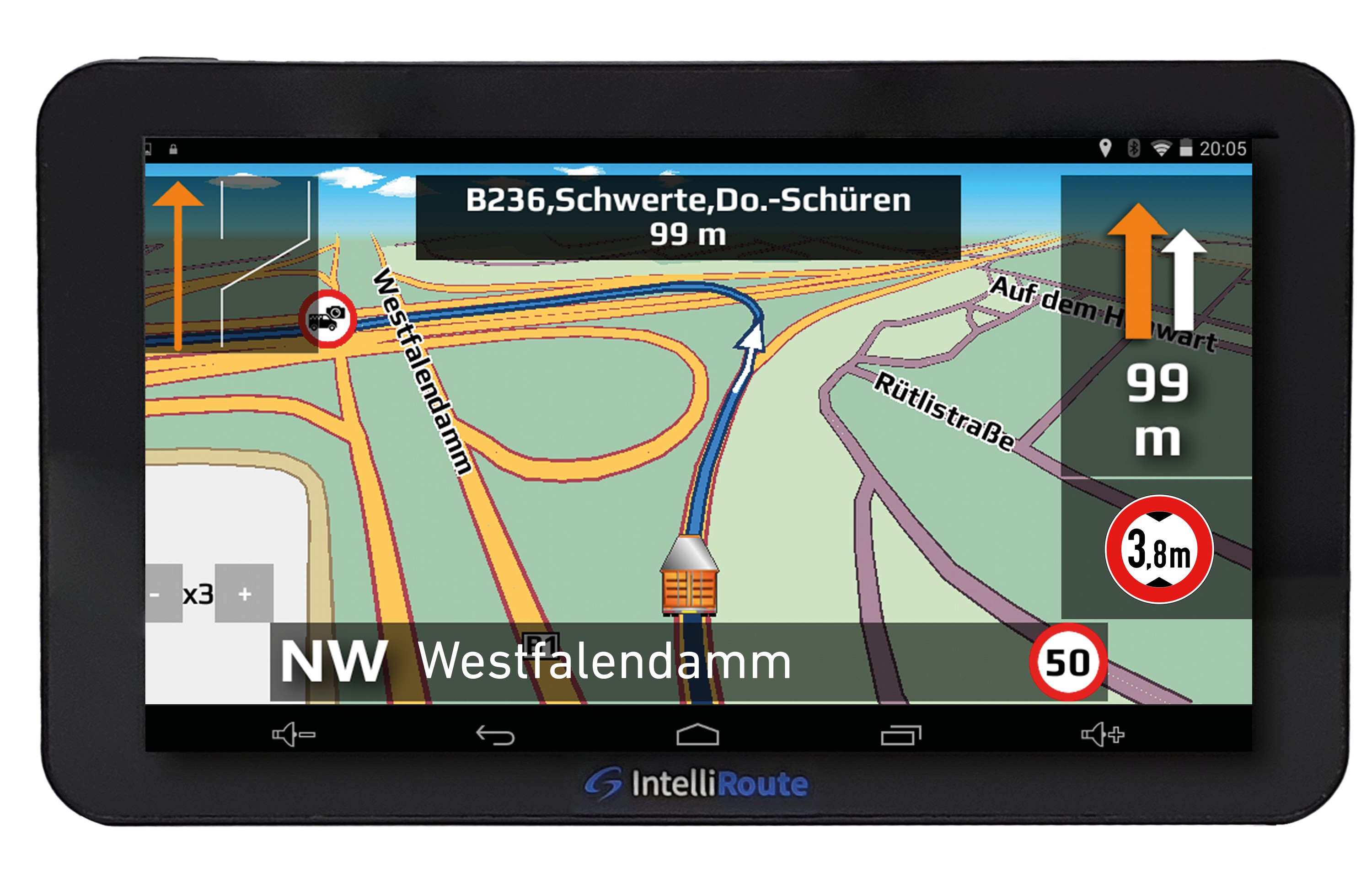
3D junction views - Junction View
Large-screen images of all important motorway junctions and exits are displayed to help you navigate your route even more safely to your destination.
Dual lane assistant
Active lane assistant (Lane Guidance) for anticipatory support, Lane Assistant Pro for the current proximity. With the lane assistants, you as the driver no longer have to think about which lane you should get into or which lane leads to which exit - that is now the job of the navigation system.
Destination guidance according to GPS coordinates
For individualists: destination guidance is possible by entering GPS coordinates. (3 different input options)
Guarantee for the latest map material
After registration and initial GPS contact, you have the option of always receiving the latest Here Global map material free of charge.
Free lifetime Here Global map updates via WiFi
IntelliRoute offers you the latest map material worth 159 * (mobile sat navs) or 249 * (built-in sat navs), which can be updated via a WiFi connection (no computer required).
Advanced road maps
IntelliRoute uses high quality digital maps from market leader Here Global. Routes can be calculated using postcodes, street names and places of interest and even by simply entering a city, town, GPS coordinates, multiple route or selected destination manually directly on the map.
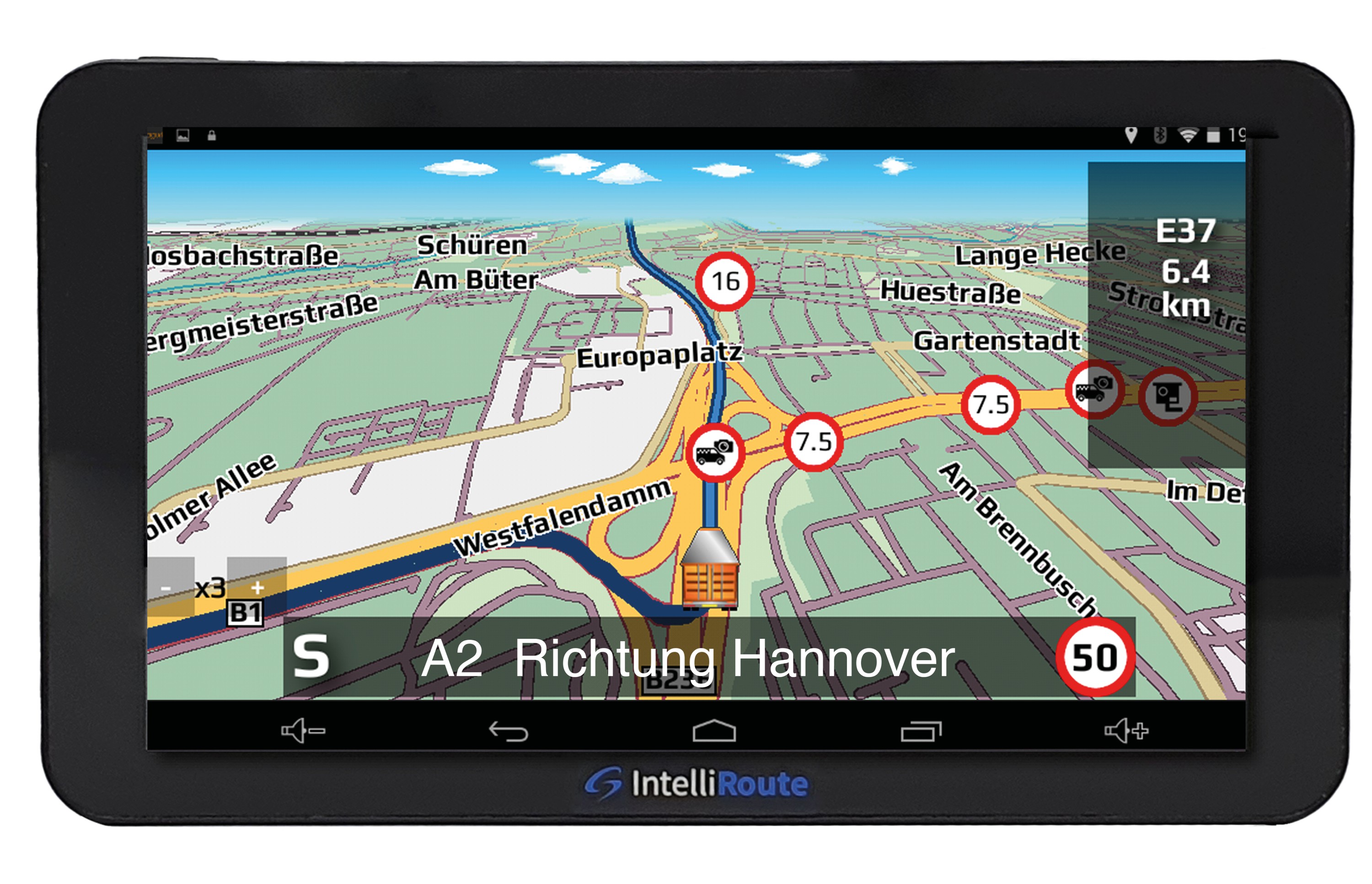
Truck-specific locations of permanently installed speed cameras
Unlike other navigation devices, our navigation systems show you speed limits that apply specifically to your vehicle size and class. You can also update the speed camera database 365 days a year, around the clock, free of charge.
While many traditional sat navs with warning systems only provide updates every 3 or 4 months, our dedicated speed camera detection team updates the database daily so you can download a speed camera the second one is added. IntelliRoute gets you from A to B with ease, ensuring your licence is not put at risk.
Advanced alerts for:
- Speed cameras
- Traffic light cameras
- Average speed measuring devices
- Roadworks cameras
- Toll cameras
- accident hazard points
- Danger zones
Day & night mode
The brightness of the screen can be set for day & night mode in the menu. Night mode makes the map view darker so that you are not dazzled.
Map view
You can choose between 2D view and 3D view for the map view.
Tunnel recalculation
If GPS reception is disrupted in a tunnel, an exact route simulation is carried out.
Over two million places of interest in Europe (many with telephone numbers)
Truck-specific points of interest with truck stops, truck refuelling stations, extended information on conventional refuelling stations, maintenance facilities for trucks, accepted truck payment cards and availability of diesel pumps. In addition to this extensive OVI list, you will also receive data on many hotels, restaurants, petrol stations, warning systems for fixed speed measurement systems, parking spaces, car parks with overnight accommodation, ATMs, airports, railway stations, shops and much more. You can reach your desired destination at the touch of a button. Your own OVI favourites can be easily imported via a csv file.
Find OVIs along the route
Select your favourite places of interest from our extensive list of OVIs and have them displayed along your calculated route within a radius of approx. 2 km.
Saving favourites
Personal destinations can be saved via the menu. These can be saved as a destination if required. They also appear as an icon in the map view.
Vehicle-specific arrival times
You can adjust the calculated arrival time to the speed at which you are travelling in order to obtain more accurate forecasts. You can either reduce the time calculation by up to 25% or increase it by up to 25%.
Avoid uphill or downhill gradients
You can specify whether the routes are calculated in such a way that they avoid undesirable inclines and declines. To do this, you can select values between 9% and 20% and exclude the corresponding inclines or declines from the calculation.
Retrofit your desired equipment
In the Google Play Store, you can download apps via WiFi as you wish and enjoy countless additional functions on your Android navigation system.
Here are a few suggestions:
- Tyre pressure warning system
- Skype telephony
- Load securing
- Transport route planning
- cheaper refuelling
- Warehouse and freight exchange
- Google Calendar
- Live traffic reports
- Driving and rest times
- E-mail for Outlook etc.
- Consumption recording
Multi-route calculation (multi-routing)
Car Guard Systems sat navs have always had the most elegant design. But they not only look good, they also offer the performance to match. Take our new and unique multi-route planning software. Multi-route allows you to calculate a single route with up to 16 different destinations by simply adding the addresses. You don't have to stop and restart the device and laboriously search for each individual address. You can now easily calculate all destinations for the day, change the order at any time, add new destinations or delete them again.
You can create up to eight itineraries with several destinations to be travelled to one after the other. If you wish, you can have the shortest route and the most sensible sequence of stages calculated automatically. You can select route options for each individual stopover. At each stop, the time and distance to the interim destination are displayed on the map.
Lorry and optional car mode
Although IntelliRoute has been specifically designed to guide HGVs and other large vehicles along safe and authorised roads, the product also has a setting for cars. Simply switch the sat nav to car mode and you will be guided to your destination on the best possible route for your car. As the navigation system is offered as a mobile version, it can easily be switched between several vehicles. That's two navigation systems in one!
Free online live traffic jam avoidance
If you drive for a living, you know how important it is to know exactly what to expect on the route.
Accurate and reliable information is a must to ensure you arrive on time for your appointments. Traffic information is fed in from hundreds of thousands of vehicles and sensors across Europe and is so up to date.
IntelliRoute's traffic jam alert service warns you about all traffic incidents in the country and lists them in order of distance from your current position or alphabetically. In addition to this overview, you can also have traffic incidents monitored that are on the route you have programmed into the system. And if there is a traffic jam on your route, you can simply have the navigation system automatically calculate a route (with an alternative route) that avoids it.
Smartphone / tablet and / or mobile internet access or WLAN required. Live Traffic Service consumes only 400 MB if used 8 hours per day / 20 days per month.
Intelligent route calculation
The route is calculated depending on the distance travelled (such as steep inclines), vehicle speed, vehicle dimensions, vehicle type, vehicle load, intended use, etc.
Navigate by OVI symbols or motorway exit numbers on the map
Search and find your destination using an OVI symbol or motorway exit number in our Search on map function.
Legal speed warning system
The speed limit on almost all roads throughout Europe is displayed on your navigation system at all times. The value for the desired speed deviation from which the warning is to be issued can be individually selected by the user.
Useful settings
In the menu, you can select which important information is displayed on the sat nav during the journey. You can choose between speed, arrival time, remaining time, automatic enlargement of the map when changing direction of travel. In the "GPS" menu, you can display the current GPS coordinates and the altitude above sea level.
We warmly welcome you. Thank you for your interest in our products!
Subject to errors and changes. Status 05.11.2022
Item number NAINTR84
| Technical characteristic | Value |
|---|---|
| Item ID | 1560 |
| Manufacturer | CAR GUARD SYSTEMS |
| Content | 1 piece |


